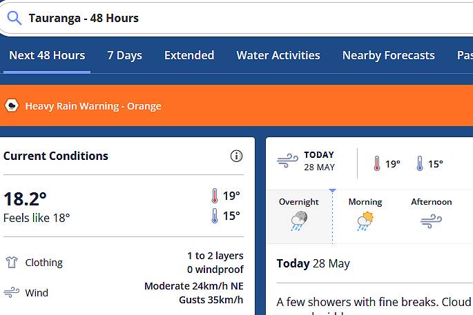
UPDATED 9.52AM: A severe weather watch issued for the Bay of Plenty is now being upgraded to a warning.
Periods of heavy rain and possible thunderstorms are being forecast for the region for tomorrow.
In its latest update, the MetService says a low and associated fronts over the Tasman Sea are expected to move east to affect the country from later today through to Tuesday, bringing strong winds and heavy rain to many parts of New Zealand.
“Heavy rain warnings and watches are in place for northern and western parts of the country and strong wind watches are also in force for the upper North Island.
“People are advised to stay up to date with the latest forecasts in case any changes are made, or further areas are added.”
 Image: MetService.
Heavy Rain Warning – Orange
Impact: Heavy rain may cause streams and rivers to rise rapidly. Surface flooding and slips are also possible and driving conditions may be hazardous.
Area: Northland
Period: 15hrs from 3pm Sun, 28 May – 6am Mon, 29 May
Forecast: Expect 50 to 80 mm of rain, mainly in the north and east. Peak rates of 15 to 25 mm/h expected in thunderstorms from this evening.
Area: Bay of Plenty about and west of Whakatane including Rotorua
Period: 16hrs from 5am – 9pm Mon, 29 May
Forecast: Expect 60 to 90 mm of rain with thunderstorms possible. Peak rates of 15 to 25 mm/h in thunderstorms.
Area: Bay of Plenty east of Whakatane and Gisborne north of Tokomaru Bay
Period: 17hrs from 10am Mon, 29 May – 3am Tue, 30 May
Forecast: Expect 100 to 140 mm of rain about the ranges, with 50 to 80 mm nearer the coast. Peak rates of 15 to 25 mm/h about the ranges with thunderstorms possible. Note, warning period may be extended.
Area: Tasman west of Motueka
Period: 15hrs from 2am – 5pm Mon, 29 May
Forecast: Expect 80 to 120 mm of rain about the ranges, with 40 to 60 mm nearer the coast. Peak rates of 15 to 25 mm/h about the ranges.
Area: Westland south of Otira
Period: 37hrs from 5am Mon, 29 May – 6pm Tue, 30 May
Forecast: Periods of heavy rain are expected during Monday and Tuesday with thunderstorms possible. Expect 220 to 280 mm of rain to accumulate about the ranges, and 80 to 120mm near the coast. Peak rates of 15 to 25 mm/h about the ranges. Note, heavy rain is expected to eased for a time Tuesday morning.
Heavy Rain Watch
Area: Mount Taranaki
Period: 11hrs from 2am – 1pm Mon, 29 May
Forecast: A period of heavy rain. Rainfall amounts may approach warning criteria.
Area: Buller
Period: 19hrs from 5am Mon, 29 May – midnight Mon, 29 May
Forecast: Periods of heavy rain. Rainfall amounts may approach warning criteria, mainly about the Paparoa Range.
Area: Richmond and Bryant ranges including the Rai Valley, also Tasman from Motueka eastwards but excluding the Nelson Lakes
Period: 14hrs from 5am – 7pm Mon, 29 May
Forecast: Periods of heavy rain. Rainfall amounts may approach warning criteria.
Area: Fiordland
Period: 30hrs from 6am Mon, 29 May – noon Tue, 30 May
Forecast: Periods of heavy rain. Rainfall amounts may approach warning criteria, mainly north of Doubtful Sounds. Note, rain is expected to ease for a time overnight overnight and early Tuesday.
Area: Auckland including Great Barrier Island
Period: 15hrs from 9pm Sun, 28 May – noon Mon, 29 May
Forecast: Periods of heavy rain with thunderstorms possible. Rainfall amounts may approach warning criteria.
Area: Coromandel Peninsula
Period: 15hrs from midnight Sun, 28 May – 3pm Mon, 29 May
Forecast: Periods of heavy rain with thunderstorms possible. Rainfall amounts may approach warning criteria.
Strong Wind Watch
Area: Northland
Period: 9hrs from 6pm Sun, 28 May – 3am Mon, 29 May
Forecast: Northeast winds may approach severe gale in exposed places.
Area: Auckland including Great Barrier Island
Period: 12hrs from 9pm Sun, 28 May – 9am Mon, 29 May
Forecast: Northeast winds may approach severe gale in exposed places.
EARLIER:
It may not look like it outside right now, but rain is still be forecast for the region today.
Cloud is expected to increase this afternoon, with the majority of heavy rain forecast for tomorrow.
The MetService says an unsettled north to northeast flow will be affecting New Zealand on Monday with several embedded fronts, turning northwest overnight Monday to Tuesday as a large trough crosses the country.
“There are already several Severe Weather Warnings and Watches in place associated with these features that extend into Monday.”
Rain warnings or watches may be needed, or are already in place, for Northland, Auckland, the Coromandel Peninsula, Bay of Plenty, northern Tairawhiti/Gisborne, Mount Taranaki, Tasman/Nelson, the Marlborough Sounds, western Marlborough, Buller, Westland and Fiordland.
“For most of these areas, there is moderate confidence a rain warning will be in place on Monday, but it is high for western Tasman, and low for Mount Taranaki, Buller and northern Westland. For Buller, Westland and Fiordland, rainfall warnings may continue into Tuesday.”
Additionally, there is moderate confidence that a wind warning will be needed in Northland and Auckland on Monday.
As the flow turns more northwesterly, there is low confidence that severe gales will be experienced in Wellington, southern Wairarapa and Marlborough on Tuesday.
A ridge is expected to briefly move over the country on Wednesday, but on Thursday, fronts approaching the South Island from the southwest are likely to bring another period of heavy rain and very strong winds.
On Thursday, there is a moderate confidence that warning amounts of rain will fall in Fiordland and Westland and a low confidence that severe northwest gales will be experienced in Southland, Otago and Canterbury.
