Mike Griffin Weatherman
I’m told all the Grey Nomads are filling up the Caravan Parks as the Rocky Show basks in the winter afternoon warm sun.
After the early fogs Tuesday/ Wednesday the days across CQ have been brilliantly sunny.
One can see the altocumulus ( floccus) middle level cloud Thursday.
The term used is three eighths cover (almost half the sky) allowing the sun’s rays to percolate through.
Farmer Steve was shocked to run into a short brief shower (SBS) near Alton Downs at 4pm Tuesday.
It only lasted a minute but cleaned off the dust on his windscreen. Looking at the radar it was the only one in Capricornia.
The cumulus cell that formed the shower was less than 500m across which is typical of the precipitation this time of year.
Noticed a clump of interesting showers on the Central Highlands late Tuesday. Here are a few of the totals (mm) of interest- Golden Mile Rd. 15, Pink Lagoon 9, Upper Retreat 7, Blackdown 6, Jo Jo Station 4, Red Hill ( Wed) 4, Funnel Creek 3, Samuel Hill 2, Dairy Creek 1, Boyne Island 1.
The early winter continued in the southern states. Snow at Perisher Valley totalled 43cm for 3 days with minus 3C early Thursday.
Makes for a welcome opening for the ski season. Perth had 11 straight days of rainfall up to Thursday. With a grand total of 177mm.
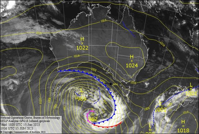
A deep low in the southern bight forms a front that will hit Adelaide/Robe/Strahan mid Saturday and impact Mildura/Melbourne/St. Helens early Sunday.
With squally showers and snow on the peaks followed bitterly cold westerly winds. This may make the Richmond/St. Kilda AFL clash a slippery rugby affair.
Are the Tigers poor swimmers. After the Aussie Cricket team won the World Test Championship. They now line up for the Ashes at Edgbaston Friday. Interestingly a low develops in the Atlantic.
A leading trough may affect England Sunday with rain for most of the day. So whoever bats first will have a distinct advantage as poor conditions may extend into next week.
INTERNATIONAL
CANADA -Record heat and drought – beginning in March and increasing in intensity during June – Wild Fires throughout Canada have burnt 5 million hectares; dubbed the worst in in recorded history. Reports of over 50 per cent of fires were caused by ‘Dry Lightning Strikes.’ One degree rise in temp equates to12 per cent rise in lightening strikes.
The other half of wildfires were deemed human unintentional by discarded cigarettes, abandoned smoldering camp fires and sparks from slashing and braking trains. Almost 1000 international Fire Fighters have been seconded (600 from US, 200 Australia/NZ and 200 Mexico – maybe more).
Smoke covered most of northern USA and reached as far south as Alabama making poor air quality( 2.5 micron smoke particles can enter the blood stream and destroy health and increased asthma attacks) . The thick smoke making a red sun Armageddon like feel causing aircraft delays and outside activity minimized. .
Scientists are saying the jetstream is weaker and allowing ” heat domes” to stay longer and set the stage for fire. This is 13 times more damaging than the 10 year average.
EL Nino is blamed for the event – American forecasters are hoping for a low over the Great Lakes to thin the smoke out. Is this a sign the El Nino will affect the southern hemisphere summer?
USA – Severe storms Colorado cause tornadoes with golf ball hail in Denver and surrounds. A FLOOD WATCH for Lakewood.
INDIA – CYCLONE “BIPARJOY” (means “Disaster” in Bengali) lashed the west coast off the Indian and about to hit Gujarat and Karachi in Pakistan by the weekend.. Wind gusts are expected to reach 150kph plus.
PANAMA – Severe Drought in Panama is forcing authorities to impose surcharges and weight limits to shipping entering the Panama Canal. The lack of water in the freshwater reservoirs is preventing the loch system from floating massive cargo ships.
FORECAST
A small high over the NSW/QLD border will cause a few early morning fogs Friday/Saturday.
As it ridges north along the coast into CQ winds should almost be calm early. Great for the boaties on Sunday Monday.
If the skies stay clear then a good chance of fog for most of the Bruce Highway from Mackay to Bundy.
Again days will be sunny and warm (25C rest of the week).
Overnight mins ( 8-9C weekends back to 10C early next week) so the perfect winter weather continues.
Tuesday into Wednesday is tricky. There is a slight shallow fog risk if the cloud breaks enough.
A weak trough to the west develops cloud along the Cap/CH border may cause a relatively cloudy day with an SBS (less than 1mm) in the afternoon.
And GKI could get a surprise overnight Wednesday afternoons stratocumulus cloud may have light drizzle (less than 1mm droplet size) from Dingo to Westwood and reach the River City plus Curtis Island overnight.
