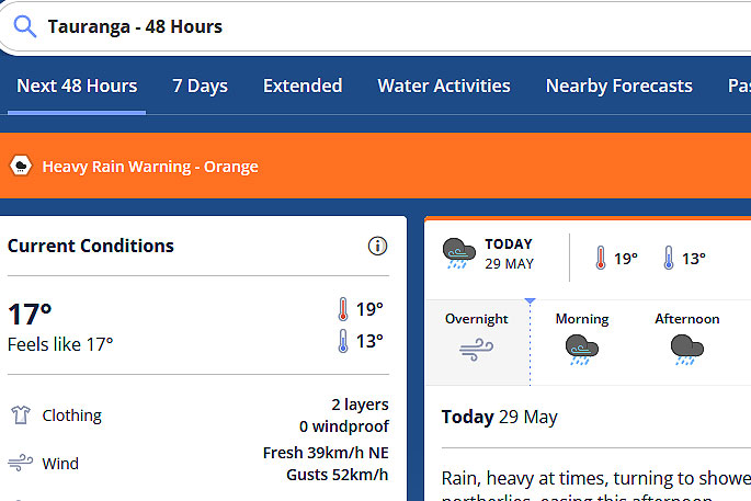
Rain, heavy at times, turning to showers this afternoon, possibly heavy, easing this evening. Strong northerlies, easing this afternoon.
That is the latest weather forecast as the MetService issues an updated severe weather warning for the Bay of Plenty.
The weather organisation is predicting heavy rain for northern and western parts of New Zealand.
“A complex low and associated fronts are moving east across the country today and Tuesday, bringing strong winds and heavy rain to some parts of New Zealand.
“Severe Weather Warnings and Watches are in place.
“People are advised to stay up to date with the latest forecasts in case changes are made, or further areas are added.”
 A weather warning, which was issued on Sunday, remains in place for the region. Image: MetService.
Heavy Rain Warning – Orange
Impact: Heavy rain may cause streams and rivers to rise rapidly. Surface flooding and slips are also possible and driving conditions may be hazardous.
Area: Bay of Plenty about and west of Whakatane
Period: 12hrs from 9am – 9pm Mon, 29 May
Forecast: Expect 60 to 90 mm of rain. Peak rates of 15 to 25 mm/h.
Area: Bay of Plenty east of Whakatane and Gisborne north of Tokomaru Bay
Period: 17hrs from 10am Mon, 29 May – 3am Tue, 30 May
Forecast: Expect 70 to 110 mm of rain about the ranges, with lesser amounts near the coast. Peak rates of 15 to 25 mm/h about the ranges, with thunderstorms possible.
Area: Tasman west of Motueka
Period: 8hrs from 9am – 5pm Mon, 29 May
Forecast: On top of what has already fallen, expect another 50 to 90 mm of rain about the ranges, with lesser amounts near the coast. Peak rates of 15 to 25 mm/h about the ranges, with thunderstorms possible.
Area: Westland south of Otira
Period: 33hrs from 9am Mon, 29 May – 6pm Tue, 30 May
Forecast: On top of what has already fallen, expect 160 to 240 mm of rain to accumulate about the ranges, and 60 to 90 mm near the coast. Peak rates of 15 to 25 mm/h about the ranges, with thunderstorms possible. Note, heavy rain is expected to ease for a time early Tuesday morning.
Heavy Rain Watch
Area: Mount Taranaki
Period: 4hrs from 9am – 1pm Mon, 29 May
Forecast: A period of heavy rain. Rainfall amounts may approach warning criteria.
Area: Buller
Period: 16hrs from 9am Mon, 29 May – 1am Tue, 30 May
Forecast: Periods of heavy rain, with thunderstorms possible. Rainfall amounts may approach warning criteria, mainly about the Paparoa Range. Note, a brief burst of heavy rain is expected Tuesday afternoon but accumulations are not expected to approach warning amounts.
Area: Richmond and Bryant ranges including the Rai Valley, also Tasman from Motueka eastwards but excluding the Nelson Lakes
Period: 10hrs from 9am – 7pm Mon, 29 May
Forecast: Periods of heavy rain. Rainfall amounts may approach warning criteria, with thunderstorms possible.
Area: Fiordland
Period: 30hrs from 9am Mon, 29 May – 3pm Tue, 30 May
Forecast: Periods of heavy rain. Rainfall amounts may approach warning criteria, mainly north of Doubtful Sound. Note, rain is expected to ease for a time overnight Monday.
Area: Coromandel Peninsula
Period: 8hrs from 9am – 5pm Mon, 29 May
Forecast: Periods of heavy rain. Rainfall amounts may approach warning criteria, especially about the ranges. Note, validity extended to 5pm.
Strong Wind Watch
Area: Canterbury High Country
Period: 7hrs from 11am – 6pm Tue, 30 May
Forecast: Northwest winds may approach severe gale in exposed places.
Warnings no longer in force
Heavy Rain Warning – Orange lifted for : Northland: Widespread heavy rain has cleared and the Warning is lifted. Note that localised heavy showers are still possible.
Heavy Rain Watch lifted for : Auckland including Great Barrier Island : The threat of rainfall amounts reaching warning criteria has passed and the Watch is lifted. Note that localised heavy showers are still possible.
Strong Wind Watch lifted for : Northland : The threat of northeast winds reaching severe gale has passed and the Watch is lifted.
Strong Wind Watch lifted for : Auckland including Great Barrier Island: The threat of northeast winds reaching severe gale has passed and the Watch is lifted.
Strong Wind Watch lifted for : Coromandel Peninsula: The threat of northeast winds reaching severe gale has passed and the Watch is lifted.
