By weather forecaster Mike Griffin
Hidden Valley in Yeppoon recorded 241mm last Sunday morning. It’s the second major downpour since March.
Thanks to Kerry Matthews, the unforecast rainfall rates were a millimetre a minute for the early hours of Sunday morning causing some flash flooding. After some investigation the rain developed from a moist tropical incision converged by the South East Trades onto the Capricorn Coast. On the 11th March Yeppoon recorded 222mm in 24hrs similar to the mid May event. Last weekend’s event dumped good showers in Rockhampton with 84mm in Frenchville and 55mm on The Range. The Airport official gauge seemed to malfunction with only 2 mm reported for Sunday. The cloud covered Capricornia and reached into the Central Highlands.
Only light falls reached Duringa and Westwood and drizzle for Clermont/Capella and Emerald. The trough system developed a low near Stradbroke Island causing 160mm on parts of the Gold Coast and 50-70mm from Bundaberg to Ballina/Coffs. Delaying flights in and out of Brisbane. Some of the totals(mm) around CQ for the event – Byfield 169, Pacific Heights 187, Yeppoon 154, Samuel Hill 107, Zilzie 102, North Rocky 84, Samuel 66, Captain Creek 65, South Rocky 59, Broadmeadow 55, Parkhurst 49, Upper Dee 45, Miriam Vale 33, Benaraby 26, Gladstone AP 25, Cracow 25, Calliope 20, Westwood 17, Theodore 14, Boyne Island 14, Hedlow 13,Banana 12, Taroom 10, Riverslea 9 , Jambin 7, Thangool 5
This strange early winter topsy turvy temperatures had Rocky recording its coldest minimum 5.9C so far this year early Wednesday on the 10th May. Followed by 16.9C on the following Thursday. A 11C temp jump! How bizarre! Could it be a record??
Add to this the heavy rain event on the weekend 15-16th followed by a fog with visibility down to 150m last Tuesday morning at 4am at Rocky Airport. Then the minimums of 18C Tuesday, 12.3C Wednesday, 10C Thursday and now 7.9C Friday makes the body feel like it’s been tasered. Other cold early morning temperatures Friday-Yeppoon 9.8C, Gladstone 10.8C with Bilo 2,4C Br!Br!Br! Elsewhere Applethorpe recorded minus 0.6C with frost from the border to the southern Central Highlands. Even Clermont recorded a minimum of 2.2C and east Capella 0.3C a slight frost. The early cold is due to a low off the southern Queensland coast now depending on the northern Tasman Sea. And a large replacement high in the Bight continues to drive cold southerly dry air from south of Tasmania well into Queensland.
INTERNATIONAL
ITALY – Worst floods in over 100 years. At least 13 deaths as locals in the northern town of Cesena had to swim over sunken cars and through floating furniture to reach high ground. Over 500mm fell inside 36hours causing the Montone River which was one of 21 rivers to inundate some 20 towns that reached the Adriatic Sea.
CROATIA – The Una River burst its banks and submerged the north western town of Bosia.
NEW ZEALAND – The third major downpour near Auckland caused a 15 yo life while caving on a school excursion.
USA – The Spring tornadoes continue. See live footage of the Dominator 3(specially built vehicle for tornado entry) intercepting a Tornado in Nebraska on the afternoon of May 12th. Drone footage shows storm chasers measuring ‘heartbeat’ of a tornado (accuweather.com)
CANADA – Over 90 Wild Fires in Alberta/British Columbia/Saskatchewan have burnt 478,000 hectares triggered by heat records. Thick smoke caused poor air quality which has drifted over the southern Canadian border into North Dakota, Minnesota and several other states.
FORECAST
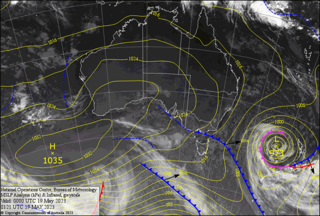
The Large high and the deep low in the Tasman continue to drive cold southerly air into Queensland. Widespread frosts have been a feature from TAS/VIC/NSW into southern Queensland. The Tasman Low ( started off the QLD Coast) looks like “smashing the North Island of NZ Tuesday. Floods and fierce winds will be a major issue. The early winter continues with more cold southerly air causing single figure minimums (frosts!?) inland over the weekend.
Crispy sunny crisp 24/25C days follow. The SW winds trajectory may protect the BOATIES during the day. Watch out for the winds overnight ramping up at the Keppels. Then the SETW slowly ramps up during Monday. Squally showers develop offshore early Tuesday and hit the coast with strong SE winds gusting close to 30 knots ( 57kph). Seas should peak about 3m. A light shower may reach the Berserkers with minimums coming back to 13-15C mid to late week.
The cloud may reach the Central Highlands with a spit. Winds gradually ease back Thursday/Friday. May see the Fitzroy and surrounds with misty white stuff in the early hours!?
