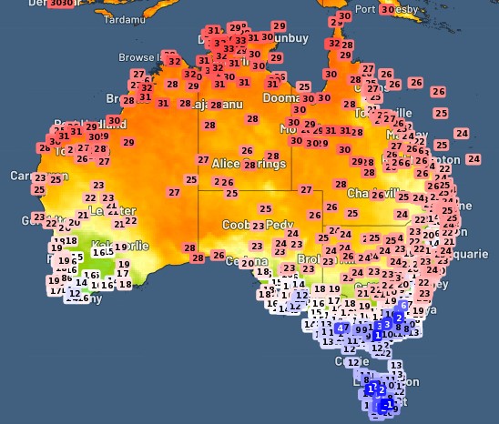
Winter? What winter? It’s June 1, but afternoon temperatures on parts of Australia’s southern coastline are not too far off the temps in our tropical north.
Virtually the whole of southern mainland Australia is having a mild day by winter standards, with the exception of the far southeast and mountain districts, where temps are cool albeit not what locals would call cold.
Indeed as we wrote earlier today, just five of Australia’s 600 official weather stations registered overnight lows below zero on Thursday night into Friday morning.
But there’s one patch of southern Australia that is having a seriously warm one this Thursday, and that’s the stretch of Southern Ocean coastline in eastern WA and western SA, where northerly winds ahead of a cold front are dragging heat from further north.
Take a look at the 3 pm temps below. The orange and yellow zone indicates the warm areas, and the coastal location showing 28°C degrees near the WA/SA border is Eucla (pop. 53), a map speck whose average June max temp is 18.7°C.

Numerous other locations are also basking in max temps up to 10 degrees above the June average. As we write this story just before 4 pm AEST:
- Nullarbor Station in SA, just over the border from Eucla, has reached 26.7°C. Its average June max 18.8°C.
- Wilcannia in western NSW is showing 26°C. Its average June max is 17.8°C.
- Albion Park, a southern suburb of Wollongong (south of Sydney) reached 24.4°C. Its average June max is 18.1°C.
A weak cold front that moved through Victoria on Thursday has spared our southernmost mainland state from the exceedingly warm (by June standards) temps further north and west, but even so, Mildura in Victoria’s far NW topped 20°C today.
Temps will cool slightly in most of the areas mentioned in coming days, but you can still expect somewhat mild temps without that biting wintry feel in most of southern mainland Australia until at least the middle of next week.
The exception is Perth, where a cold front should drop temps dramatically to the mid-teens by Tuesday. Snow-watchers will be keeping a close eye on whether that system then maintains its strength as it tracks east.
